Tracking the 2026 fires across the Blue Mountains
Update from Andrew Addessi, BMLT Stewardship & Restoration Director
As rain returns to the inland Pacific Northwest and the air clears, the summer of 2026 will likely remain in the memories of many across the Blue Mountains. Wildfires directly affected or threatened many lands important to our communities, and months of smoke and unhealthy air were an ever-present reminder of the scale of this fire season.
In the northern Blue Mountains, the Hagan and Paradise Fires were ignited by dry lightning storms in mid-July. Since then, they have burned for months across rugged, roadless terrain in Walla Walla’s municipal watershed, the North Fork Umatilla Wilderness, and surrounding areas of the Umatilla National Forest.
U.S. Forest Service staff and many associated emergency fire personnel have worked valiantly throughout the summer to limit the spread and impacts of these fires and protect communities, infrastructure, natural resources, and public and private lands.
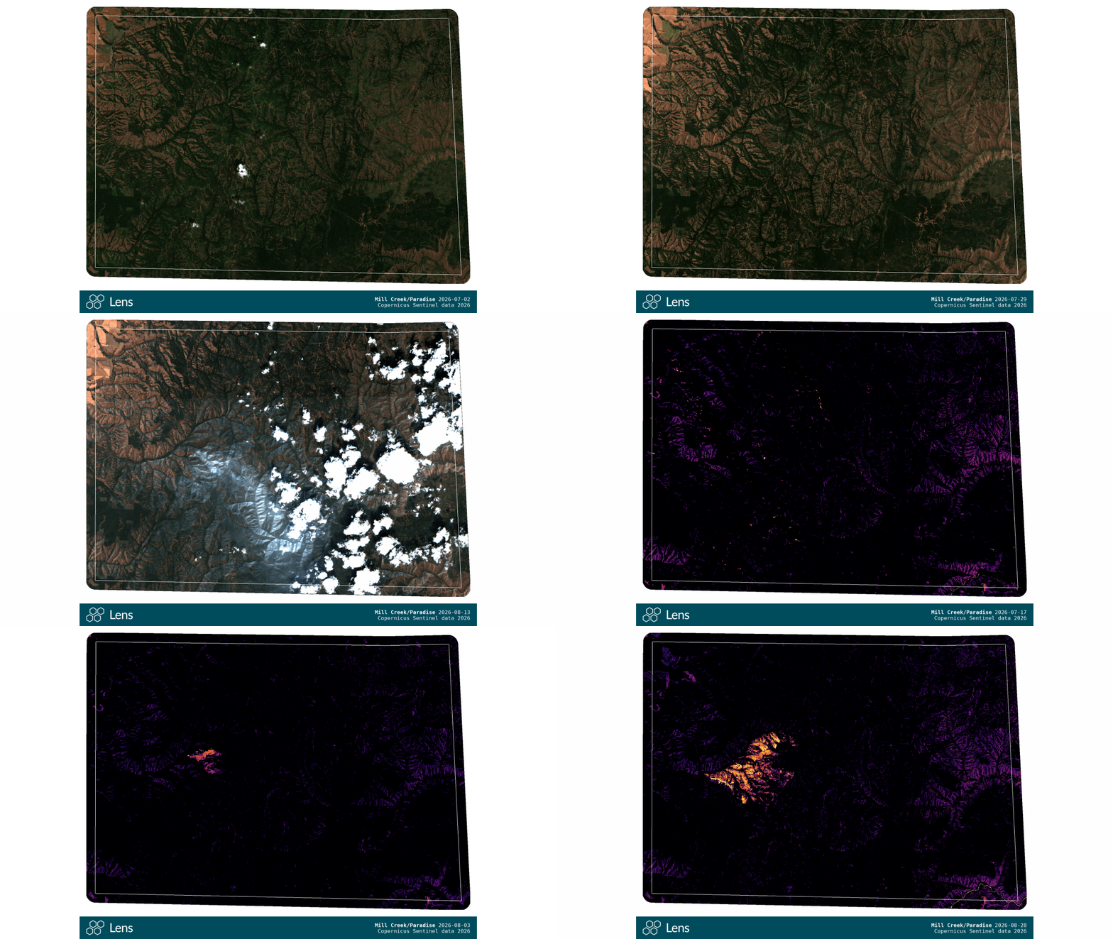
BMLT has been tracking these fires remotely using Lens, a web platform developed by Upstream Tech. We have reviewed publicly available Sentinel-2 satellite imagery and burn-severity images to get an early assessment of fire effects and impacts, particularly on the Horseshoe Prairie Nordic Ski Area and other backcountry trails valued by our communities and maintained by our BMLT Blues Crew volunteers.
The good news is that the Hagan Fire appears to have had minimal impact on Horseshoe Prairie, and the Nordic trail network looks largely unaffected aside from preemptive fire breaks. BMLT will continue working with the Umatilla National Forest to monitor conditions, address safety concerns, and determine when public access can safely resume at Horseshoe Prairie. As of September 2026, most recreational areas remain closed to the public.
Hagan Fire 2026

It is still too early to determine the condition of the North Fork Umatilla Wilderness trail network, but satellite imagery shows extensive fire effects across portions of these trails.
This type of imagery is just one tool for investigating the effects these fires have had on our forests, waters, and wildlife. But it does provide a powerful way to visualize the scope and scale of the fires, explore how familiar places have been affected, and track how these landscapes recover over time.
While emergency fire management staff continue to lead immediate response and rehabilitation efforts, please respect all current U.S. Forest Service closures and refer to the Umatilla National Forest Alerts page for the most up-to-date restrictions and closures. For broader incident information, updates, and emergency response resources, visit the Hagan & Paradise Fire Information page.
Mill Creek/ Paradise Fire 2026

Explore the imagery
Explore the broader Hagan and Paradise fire footprints to see a mosaic of low, moderate, and high severity effects.
BMLT is able to share interactive maps of these fires with you through the Lens platform, where updated, publicly available Sentinel satellite imagery has been available every ~3–7 days. The viewers linked below let you compare imagery using the center slider, zoom and rotate the landscape, use the 3D viewer, or change the surrounding basemap to better understand the fires in relation to surrounding forests and terrain.
(Tip: Press "Shift and +" to brighten the map panels. "-" will darken them.)
Hagan Fire:
July 2, 2026 vs August 28, 2026 True Color Imagery Comparison (Copernicus Sentinel data; 10m resolution)
August 23, 2026 Burn Index vs True Color Imagery Comparison (Copernicus Sentinel data; 10m resolution)
Paradise (Mill Creek) Fire:
July 2, 2026 vs August 28, 2026 True Color Imagery Comparison (Copernicus Sentinel data; 10m resolution)
August 28, 2026 Burn Index vs True Color Imagery Comparison (Copernicus Sentinel data; 10m resolution)
A note on interpreting the imagery:
Sentinel imagery is relatively coarse at 10-meter resolution, and burn-index imagery should be interpreted cautiously. Large areas show intense burning, although many of the strongest burn signals occur along grassy and shrubby foothills and ridge slopes, where ecological effects may be relatively short-lived. In denser forests, before-and-after true-color imagery can provide a better indication of tree mortality and impacts to forest structure. In many places, the fire may ultimately be beneficial, renewing vegetation and diversifying habitats while also reducing accumulated forest fuels that would be available in a future fire.